Go-BGC, GO-SHIP? Go Fish!
Who’s who in the soup of acronyms
26 February 2024
It’s true that science seems to be a sea of acronyms. Components, equipment, programs, agencies…everything is referred to by a shorter title, usually the letters that stand in for the longer name. I will try to define just a few acronyms that we use around the ship on this cruise so you won’t have FOMO. If the descriptions below are still too confusing, don’t worry, I’ll tell you what you NTK (need to know)!
Float Programs
GO-BGC—Global Ocean Biogeochemistry Array. GO-BGC utilizes autonomous robotic floats to measure temperature, salinity, pH, nitrate, chlorophyll, suspended particles, light, and derived parameters DIC, pCO2 and total alkalinity in the ocean from the surface to 2000m. These floats can operate continuously for years in all weather conditions, providing near real-time observations of ocean biogeochemistry and ecosystems throughout the world’s oceans.
NTK: GO-BGC deploys biogeochemical floats throughout the world ocean.
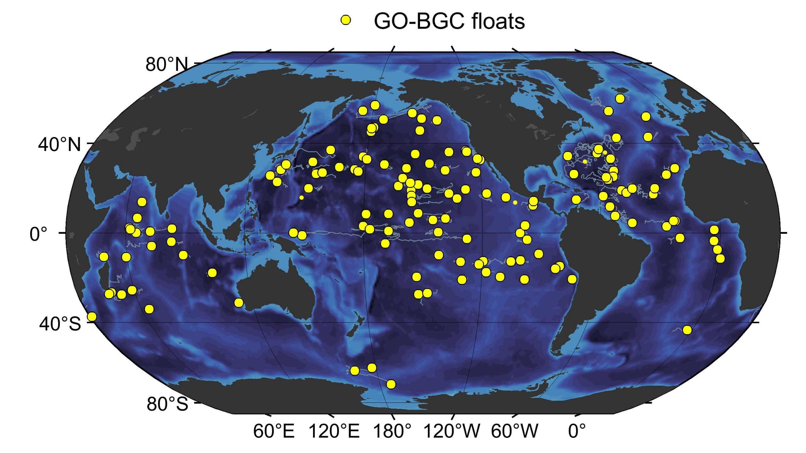
GO-BGC Array Status – lets you see where the GO-BGC floats have been deployed, where the floats are now, and if the floats are active or inactive. There are links to current and future deployment locations as well as to interactive data tables to enable access to the float data.
SOCCOM—The Southern Ocean Carbon and Climate Observations and Modeling project. SOCCOM is an NSF-sponsored program focused on unlocking the mysteries of the Southern Ocean and determining its influence on climate. Housed at Princeton University and administered by the Atmospheric and Oceanic Sciences Program, SOCCOM draws on the strengths of teams of investigators across the U.S. as well as participating in international observational and simulation efforts.
NTK: SOCCOM deploys biogeochemical floats in the Southern Ocean.
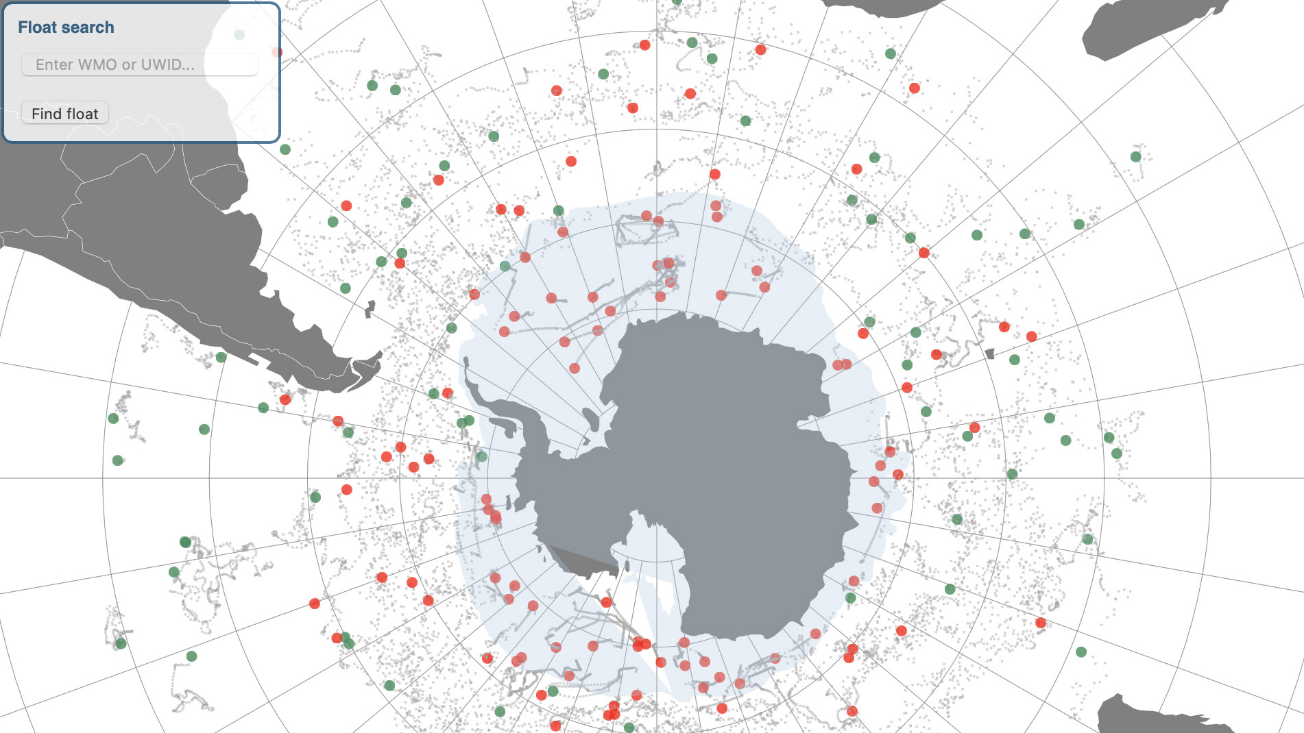
SOCCOM Map Room is where to go if you want to see where the SOCCOM floats have been deployed, where the floats are now, and if they are active or inactive.
Argo— Argo is an international program that represents a global array of ~4000 free-drifting instruments, spaced about every 3° of latitude and longitude, moving up and down in the water column from the sea surface to 2000 meters every 10 days, and profiling temperature, salinity, and depth during every ascent to the surface. The name Argo (not an acronym) was chosen because the array of floats works in partnership with the Jason earth observing satellites that measure the shape of the ocean surface.
NTK: Argo profiling floats measure temperature and salinity throughout the world ocean.
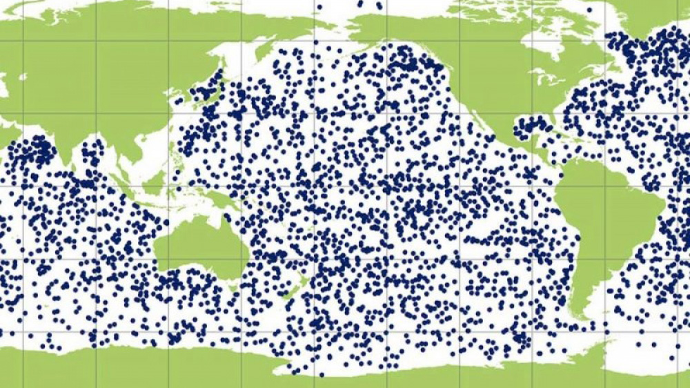
Argo Status – provides a broad overview of the Argo program and shows where all the Argo floats are (these include the SOCCOM and GO-BGC floats).
GO-BGC/SOCCOM Partner Institutions
MBARI— Monterey Bay Aquarium Research Institute. MBARI is a non-profit oceanographic research center advancing marine science and engineering to understand our changing ocean. Located in Moss Landing, California.
NTK: The GO-BGC Array is administered by MBARI, who supplies the sensors for the floats.
UW—The University of Washington. The School of Oceanography is at the forefront of creating knowledge and understanding about the ocean through observation, theory, modeling and technological innovation. Located in Seattle, Washington.
NTK: UW engineers help assemble the floats, test and calibrate the sensors, and ship them out for deployment. (both Apex and Navis)
WHOI— Woods Hole Oceanographic Institution. WHOI is an independent organization dedicated exclusively to ocean research, technology, and education. They combine state-of-the-art science, engineering, and ship operations to unravel the mysteries of the deep and devise science-based solutions to planet-wide problems. Located in Woods Hole, Massachusetts.
NTK: WHOI engineers help assemble the floats, test and calibrate the sensors, and ship them out for deployment. (mostly Navis)
SIO— Scripps Institution of Oceanography. Scripps Institution of Oceanography at UC San Diego works to understand and protect the planet and find solutions to our most pressing environmental challenges. Located in La Jolla, California.
NTK: SIO engineers help assemble the floats, test and calibrate the sensors, and ship them out for deployment. (Solo-II)
Princeton—Princeton University. Princeton is one of the top universities in the world. Their undergraduate and graduate programs emphasize learning, creativity, innovation and collaboration. Located in Princeton, New Jersey.
NTK: The SOCCOM project is headquartered at Princeton and Princeton also helps provide project management for GO-BGC.
Other Programs
GO-SHIP—Global Ocean Ship-based Hydrographic Investigations Program. GO-SHIP brings together scientists with interests in physical oceanography, the carbon cycle, marine biogeochemistry and ecosystems, and other users and collectors of ocean interior data, and coordinates a network of globally sustained hydrographic sections as part of the global ocean/climate observing system including physical oceanography, the carbon cycle, marine biogeochemistry and ecosystems.
NTK: GO-SHIP cruises systematically monitor the world ocean over time.
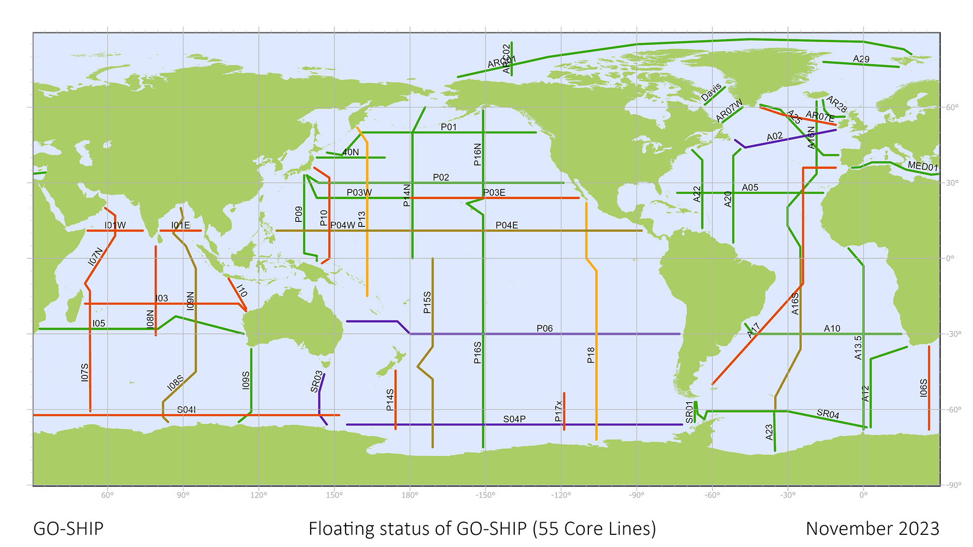
GO-SHIP Reference Sections are repeat hydrographic sections that are, in general, coast-to-coast or coast-to-ice.
NSF— National Science Foundation. NSF is an independent federal agency that supports science and engineering in all 50 states and U.S. territories. Located in Alexandria, Virginia.
NTK: Many of the programs onboard are supported with NSF funding.
ODF— The Oceanographic Data Facility at Scripps Institution of Oceanography offers data processors and chemistry technicians that can be hired for work at sea and for shore-based projects. ODF provides comprehensive hydrographic data collection and processing, as well as water sample collection and high-accuracy chemical analysis.
NTK: We have a team of ODF technicians onboard helping with water sample collection and analysis.
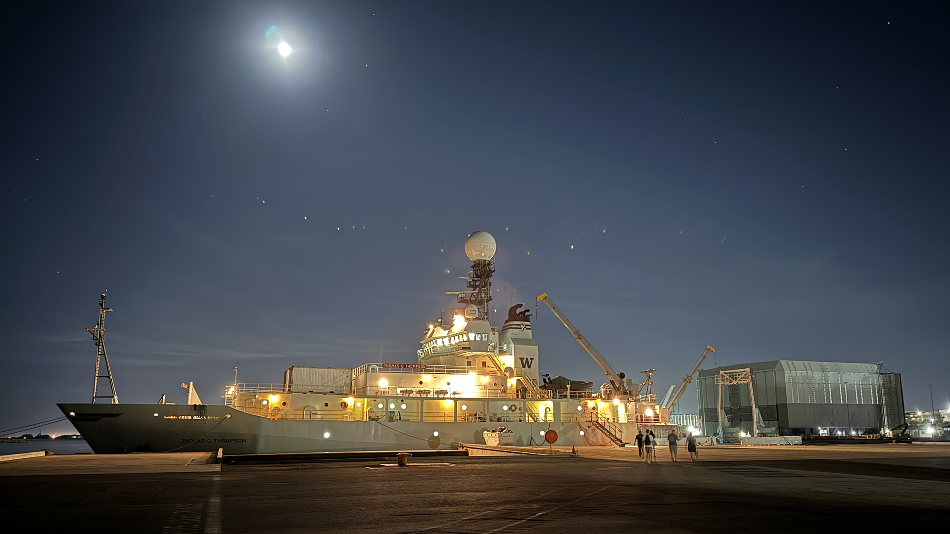
R/V Thomas G Thomson at the dock under a bright moon, as members of the science team board the ship
There are so many more programs and institutions represented onboard with us than are listed here. We will be highlighting them throughout the expedition to let you know how they are helping us learn more about the world ocean!
Questions?
I’d love to answer any questions that you or your students have! Please feel free to send them to me at jenn@deepbluescience.com or find me on Instagram at @deepbluescience. As long as the wi-fi holds out, I’ll do my best to answer them.
All images are by Jennifer Magnusson unless otherwise noted.
- Expedition Logs
- 2024 GO-SHIP I08S
- I08S Intro
- Float Checks
- Alphabet Soup
- Trieste
- Weekly Update #1
- Nurse Jennie
- Raphael
- Jess – Salts
- Fishstick!
- Cora – pH
- Swampii
- Southern Ocean
- Seawolves Explore
- Ferruccio
- Abby – pH
- Belmont Bullkelp
- Onboard Sampling
- Vincent – Dissolved Oxygen
- Elisa – Dissolved Oxygen
- Marshal – Alkalinity
- Ruth – CTD
- Vic – DOM
